Friday, February 23, 2024

Volcanic Activity in Algeria


Volcanic Activity in Algeria

by Laurel Bowen - Week 5 Blog Post for Geology 9 with Ana Garcia Garcia

Volcano Drawing Images – Browse 41,588 Stock Photos, Vectors, and Video |  Adobe Stock

Algeria country profile - BBC News

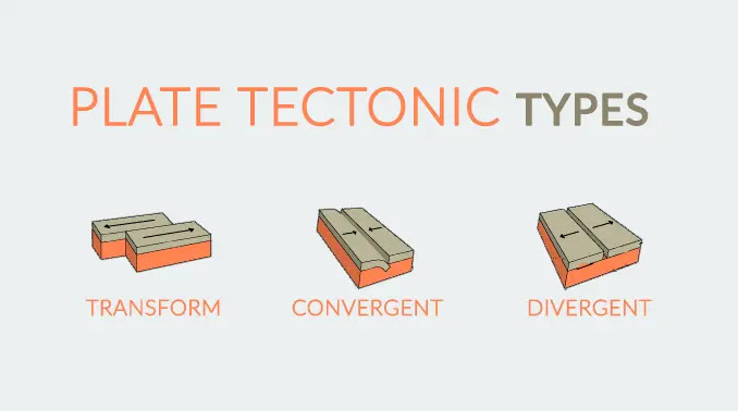
  Volcanoes are natural formations on Earth's surface where molten rock, ash, and gases from beneath the Earth's crust are expelled. This happens through openings in the Earth called vents, allowing the release of built up pressure. The Earth's outer shell, the crust, is divided into many large and rigid plates that float on the semi-fluid layer of the mantle beneath them. Volcanoes occur at plate boundaries, where these plates interact. When it comes to preparing for a volcanic eruption, scientists and authorities follow a series of steps to monitor, forecast, and communicate potential volcanic activity. By analyzing data from monitoring instruments, scientists can make predictions about volcanic activity. Making these predictions is called forecasting.  Changes in seismicity, gas emissions, ground deformation, and other indicators may suggest an upcoming eruption. To communicate the level of potential volcanic threat, authorities use a system of volcanic alert levels. Once a potential threat is identified, authorities communicate this information to the public through various channels and depending on the level of volcanic threat, authorities may develop evacuation plans for nearby communities.

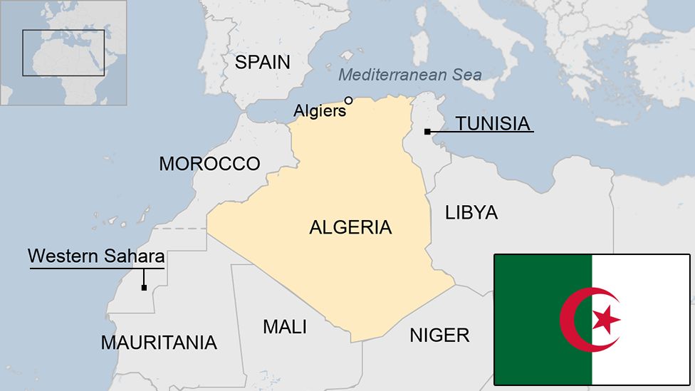
    According to Think Hazard, Algeria's volcanic hazard risk is very low, but there are still volcanoes located in Algeria. Many of the volcanoes in Algeria are considered extinct or dormant, meaning they are not currently active. The Hoggar Mountains, also called the Ahaggar Mountains, are in the south of Algeria. In the past, this area had volcanoes, and you can see old volcanic structures and lava flows in the landscape. Tassili n'Ajjer, found in southeast Algeria, is a big flat area known for cool rocks and ancient rock art. Even though there are no active volcanoes there now, you can still find rocks from past volcanic activity in some places. The Tell Atlas is a group of mountains in the north of Algeria, running along the coast. While it doesn't have many volcanoes, this region has had movements in the Earth's crust and shaking events called earthquakes. The northern part of Algeria, especially along the Mediterranean coast, doesn't usually have volcanoes. Instead, it often has shaking from the Earth's plates moving around. The Smithsonian Institution National Museum of Natural History Global Volcanism Program's website states that there are three Holocene volcanoes, meaning volcanic structures or landforms that have formed during the geological time period that began around 11,700 years ago and continues to the present day. There are also three Pleistocene volcanoes, meaning having volcanic activity that occurred about 2.6 million to 11,700 years ago.

Recent Volcanic Activity in the Hoggar Swell, Algeria |
Hoggar Swell, Algeria


Works Cited

“Global Volcanism Program: Algeria Volcanoes.” Smithsonian Institution | Global Volcanism Program, volcano.si.edu/volcanolist_countries.cfm?country=Algeria#:~:text=Algeria%20has%203%20Holocene%20volcanoes. Accessed 24 Feb. 2024.

“Natural Disasters (New Version Coming Soon).” Open Geography Education, www.opengeography.org/natural-disasters-new-version-coming-soon.html. Accessed 23 Feb. 2024.

Think Hazard, thinkhazard.org/en/. Accessed 23 Feb. 2024.


Wednesday, February 7, 2024

Earthquakes in Algeria


Algeria and Earthquakes

by Laurel Bowen - Week 3 Blog Post for Geology 9 with Ana Garcia Garcia


This week we will be discussing Algeria's seismicity. Seismicity refers to the occurrence and intensity of earthquakes in a specific region, shaped by geological factors like tectonic plate boundaries and fault lines. Regions with high seismicity are prone to more frequent and potentially stronger earthquakes, necessitating focused efforts on earthquake preparedness and risk mitigation. Algeria experiences a moderate level of seismic activity, although occasionally significant earthquakes can happen. The country is considered one of the most earthquake-prone regions due to its geographical positioning, geological makeup, and the susceptibility of its constructions to seismic events. Back in 2003, the Algerian Red Crescent Society (ARCS) launched a project to train disaster response teams in all 48 Algerian governorates within three years. The International Federation provided equipment, and the French Red Cross offered training. ARCS assessed vulnerability in regions like Annaba, Skikda, Oran, Boumerdes, and Ouargla. Simultaneously, plans were implemented to establish first aid centers in all governorates, and ARCS distributed informative leaflets on earthquake preparedness. The urgency stemmed from past disasters, including a 2003 earthquake that killed 3,000, heavy rains in 2002 causing numerous deaths, and a 1980 earthquake claiming 5,000 lives. In summary, Algeria acknowledges its susceptibility to seismic activity, leading to a proactive and comprehensive approach in earthquake preparedness and risk mitigation. The initiatives undertaken by the Algerian Red Crescent Society, in collaboration with international partners, reflect a commitment to enhancing resilience in the face of seismic challenges.


Works Cited

Oussama Sohaib Mazari a, et al. “Creating a Homogenized Earthquake Catalog for Algeria and Mapping the Main Seismic Parameters Using a Geographic Information System.” Journal of African Earth Sciences, Pergamon, 23 Feb. 2023, www.sciencedirect.com/science/article/abs/pii/S1464343X23000687#:~:text=Algeria’s%20seismicity%20can%20be%20considered,Yelles%2DChaouche%2C%202022).

“Natural Disasters (New Version Coming Soon).” Open Geography Education, www.opengeography.org/natural-disasters-new-version-coming-soon.html. Accessed 7 Feb. 2024.

Think Hazard, thinkhazard.org/en/. Accessed 7 Feb. 2024.

UNDP and Indigenous Peoples: A Policy of Engagement, www.undp.org/sites/g/files/zskgke326/files/publications/UNDP_Policy_of_Engagement_with_Indigenous_Peoples.pdf. Accessed 8 Feb. 2024.


Sunday, February 4, 2024

Algeria's Complex Tectonic Plate Boundaries


Algeria's Tectonic Plate Boundaries

by Laurel Bowen - Week 2 Blog Post for Geology 9 with Ana Garcia Garcia 


Tectonic plates are large parts that make up the lithosphere layer of the Earth.  These plates can collide, pull apart, and rub against each other, causing many natural hazards to occur where they plates meet at. The place where they meet is known as a plate boundary. There are three tectonic types. Transform type, which is the plates rubbing against each other, convergent type, which is the plates colliding, and divergent type, which is the plates pulling apart, Algeria belongs to the African tectonic plate, but the Northern part of Algeria holds the boundary for the Eurasian plate, one of the African plates's neighbors. The two plate's create a convergent tectonic type. Convergent boundaries can cause subduction zones, where one of the plates go down under the other, or form mountains by going up when the plates collide. Northern Algeria is very mountainous, which was formed from the convergent boundary. In Algeria there are common hazards such as earthquakes, landslides, and flooding, which is caused by the plate boundaries drifting. Next week we will be discussing Algeria's  seismicity and what the country is doing to prevent earthquake catastrophe. 


Works Cited

Earthhow. “Plate Tectonic Types: Divergent, Convergent and Transform Plates.” Earth How, 23 Sept. 2023, earthhow.com/plate-tectonics-types-divergent-convergent-transform-plates/.

Hamai, Lamine, et al. “Flexural Behaviour of the North Algerian Margin and Tectonic Implications.” OUP Academic, Oxford University Press, 4 Apr. 2015, academic.oup.com/gji/article/201/3/1426/769910.

Oer Commons, oercommons.org/courses/natural-disasters-new-version-coming-soon/view. Accessed 5 Feb. 2024.

Tectonic Inversion and Geomorphic Evolution of ... - Wiley Online Library, agupubs.onlinelibrary.wiley.com/doi/10.1029/2020TC006369. Accessed 5 Feb. 2024.

“Tectonic Plates of the Earth.” Tectonic Plates of the Earth | U.S. Geological Survey, www.usgs.gov/media/images/tectonic-plates-earth. Accessed 4 Feb. 2024.

Getting to Know Algeria and the Differences Between Hazards, Disasters and Catastrophes

Getting to Know Algeria and Differences Between Hazards, Disasters, & Catastrophes

by Laurel Bowen - Week 1 Blog Post for Geology 9 with Ana Garcia Garcia 

Algeria's location on the map found from 
Encyclopedia Britannica, Inc. 


One of the most famous stock images of
Algeria by Leonid Andronov found
on Getty Images


Algeria is known for its hospitality and booming handicraft industry, consisting of carpets, ceramics, pottery, clothing, leather work, glass art and more, as stated in the Algerian Embassy's official website. Located on the continent of Africa, Algeria is one of the largest countries that border the Mediterranean Sea. Algeria has 58 provinces, consisting of a population around the size of 44.18 million people. With this size of a population, Algeria has a vast culture, heavily influenced by Arab and Berber culture, and Islamic heritage. Algeria's most common hazards that the country experiences is flooding, fires, and earthquakes. This can quickly turn into disasters, which Algeria has experienced quite a bit of with it's severe and dangerous flooding. These floods have turned into catastrophic events before, killing thousands. Hazards can easily turn into disasters, leading to catastrophes, but there are a few key differences between the three. According to the textbook Natural Disaster and Human Impacts, hazards are "any natural process or even that poses a direct threat to the human environment," a disaster is "the effect of a hazard on society," and a catastrophe is said to be a "a massive disaster that greatly impacted the human environment and requiring significant expenditure of time, money, and resources for response and recovery." The hazards and disasters that commonly happen in Algeria has been found to be have significant economic losses, which is mainly caused by the placement of Algeria on its tectonic plate. In the next blog post we will discuss Algeria's plate boundaries in regard to tectonic plates and how the effects the country.


Works Cited

“Algeria.” Culture of Algeria - History, People, Clothing, Traditions, Women, Beliefs, Food, Customs, Family, www.everyculture.com/A-Bo/Algeria.html#:~:text=The%20national%20identity%20of%20Algeria,to%20include%20other%20Arab%20nations. Accessed 4 Feb. 2024.

“Algeria.” Encyclopædia Britannica, Encyclopædia Britannica, inc., 26 Jan. 2024, www.britannica.com/place/Algeria#/media/1/15001/208371.

Culture:Language,Literature & Art, www.algerianembassy.co.in/news/culturelanguageliteratureart/#:~:text=Algeria%20has%20a%20thriving%20handicrafts,Zab%20carpets%20and%20Kabyle%20jewelry. Accessed 4 Feb. 2024.

Foreign, Commonwealth & Development Office. “Algeria Travel Advice.” GOV.UK, GOV.UK, 25 July 2023, www.gov.uk/foreign-travel-advice/algeria.

Natural Disasters | OER Commons, oercommons.org/courseware/lesson/26151/overview. Accessed 5 Feb. 2024. 

The Most Dangerous Hazards in Algeria

The Most Dangerous Hazards in Algeria  by Laurel Bowen - Week 16 Blog Post for Geology 9 with Ana Garcia Garcia Algeria topographic map Alge...